A geometry written in dust.
High on Mount Sharp, Curiosity has entered a field of centimeter-scale polygons so continuous that it fills a 360-degree view. The pattern is real. The process that made it is still an open case.
PLANETARY GEOLOGY · JULY 30, 2026 · 12 MIN READ
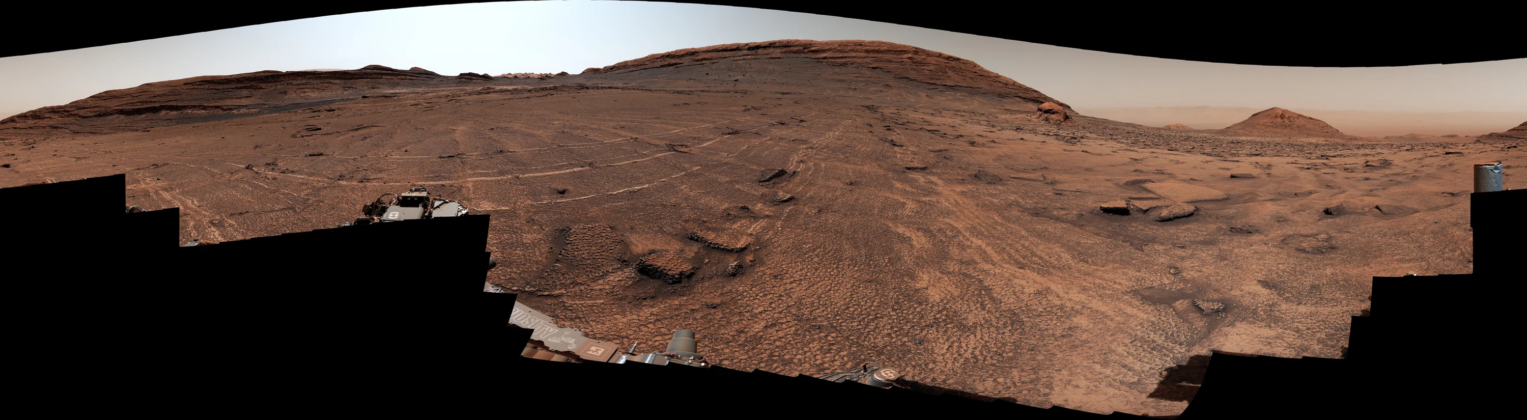
A full-circle Mastcam panorama of Valle Grande, assembled from images captured June 19–20, 2026, on sols 4930–4931. Polygonal textures cover the foreground and continue around the rover; the sand-capped butte Miraflores rises in the distance. Credit: NASA/JPL-Caltech/MSSS, PIA26729. [1]
Field notes at a glance
4–8 centimeters — width of the individual polygonal cells
360 degrees — the panorama’s complete sweep around the rover
Sols 4930–4931 — June 19–20, 2026, when the panorama was recorded
6 meters — approximate height of the nearby butte Miraflores
37.62 kilometers — Curiosity’s total drive distance by sol 4966
~1.35 kilometers — elevation gained since Bradbury Landing by late July 2026
In this story
A sea of polygons
Where Curiosity is on Mars
Why an old crack can stand as a ridge
Three processes, one pattern
How the rover is testing the field
The mud cracks Curiosity has seen before
What the pattern adds to Gale Crater’s history
What is known, inferred and still open
At first glance, the ground ahead of Curiosity looks almost tiled.
Dark seams and low ridges divide the surface into thousands of compact cells. Some are four-sided, some five- or six-sided, and none is perfectly regular. Yet at panorama scale they merge into a startling order: a honeycomb draped over a Martian valley, broken only by loose stones, sand and the low silhouette of a butte.
The mission team calls the valley Valle Grande. NASA calls the structures polygonal fractures, each about 1.5 to 3 inches—4 to 8 centimeters—across. Curiosity has encountered polygon patterns many times during its ascent of Mount Sharp, but not a field with this visual continuity. In the rover’s June panorama, the texture reaches in every direction the cameras can see. It even climbs the flanks of Miraflores, a six-meter, sand-capped pile of rock nearby. [1]
The immediate temptation is to call them mud cracks. That is one plausible explanation, and Curiosity has found genuine ancient mud cracks elsewhere. But Valle Grande is not yet a solved landscape. Thermal stress can fracture material into polygons. Sediment can crack while it is being buried and compacted. Groundwater can later fill those fractures with minerals. Wind can then erase the softer rock and leave the filled cracks standing in relief.
What the panorama gives us is the geometry. What the rover is now gathering—junction angles, close-up texture and chemistry—may reveal the history.
01 A field that does not stop
The panorama was made by Curiosity’s Mast Camera, or Mastcam, from frames taken on sols 4930 and 4931. Because the rover photographed a complete circle, the published strip joins its two ends: the left and right edges are neighboring directions in the real landscape, not opposite ends of a valley.
That matters. A conventional photograph can make a patch of patterned ground look larger than it is. A full-circle mosaic shows that the polygons are not confined to one photogenic slab. They surround the rover.
“This sea of polygons took our breath away,” project scientist Ashwin Vasavada said in NASA’s release. The team’s response was not simply to photograph it, but to measure the shapes and compare the chemistry of the ridges and the material inside them. [1]
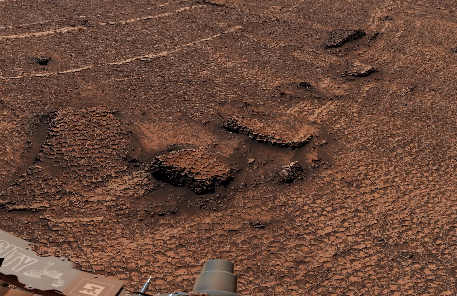
A closer view resolves the field into low, resistant edges surrounding shallow cells. The geometry is an observation; the process that produced it remains under study. Credit: NASA/JPL-Caltech/MSSS, PIA26729, Figure A. [1]
The scale is intimate. A single cell would fit under a coffee mug. The field becomes grand only through repetition. If the fractures are preserved in bedrock rather than merely traced in loose surface dust, their continuity also implies that the stress which created them acted across a substantial exposure under broadly similar conditions.
That last sentence is an inference, not a verdict. Even within one panorama, erosion can expose different levels of a fracture network, and windblown material can conceal parts of it. The field’s visible reach does not tell us how far it continues underground or beyond the horizon.
Valle Grande is visually uniform at landscape scale, but its origin will be decided at centimeter scale—where ridges meet, minerals change and individual layers cross the fractures.
02 Where on Mars?
Curiosity landed in the northern interior of Gale Crater at 4.5895° south, 137.4417° east. Gale is a 154-kilometer-wide impact basin straddling the boundary between Mars’ cratered southern highlands and smoother northern lowlands. At its center rises Aeolis Mons—Mount Sharp—a layered mound about 5.5 kilometers above the crater floor. [2] [3]
The rover touched down on August 5, 2012 in Pacific time—August 6 in Coordinated Universal Time—then drove across the crater floor and reached the lower slopes of Mount Sharp in 2014. By sol 4966, NASA’s live traverse map reported 23.38 miles, or 37.62 kilometers, of driving. A mission update in July put the cumulative elevation gain at about 4,400 feet, or 1.35 kilometers. [4] [5]
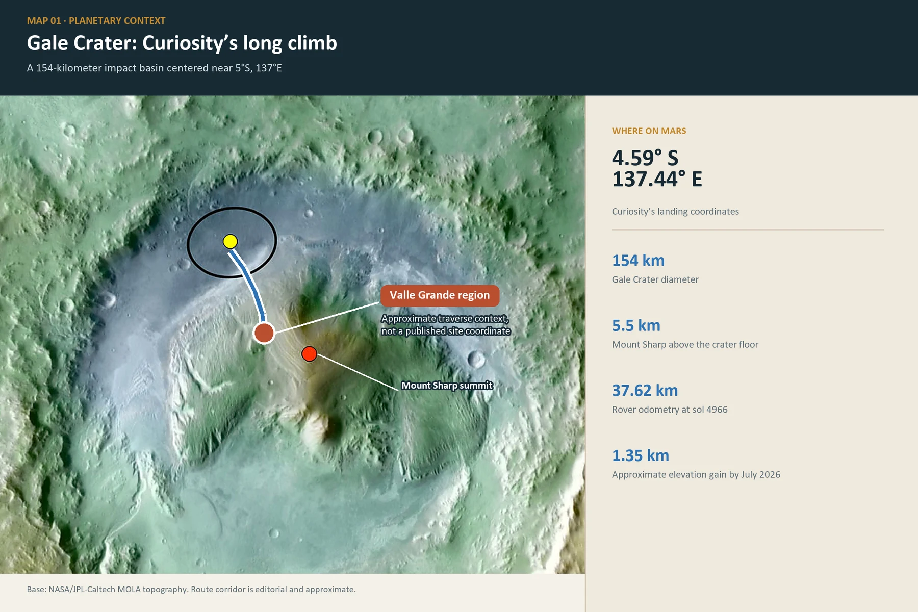
Gale Crater in MOLA topographic context. The yellow marker and ellipse indicate Curiosity’s landing area; the red dot in the source map marks Mount Sharp’s summit. The blue route is a deliberately simplified editorial corridor, and the Valle Grande marker is approximate because NASA’s public release does not publish a standalone coordinate for the named field. Base image: NASA/JPL-Caltech. Graphic: Apeira Astra. [6]
Explore Gale Crater in 3D
The pin opens the northwestern Mount Sharp vicinity in Apeira Astra’s Mars atlas. NASA has not published a standalone coordinate for Valle Grande, so this is deliberately marked as an approximate editorial location rather than an exact rover fix.
“High on Mount Sharp” does not mean Curiosity is approaching the summit. The rover is traversing the mountain’s northwestern flank, sampling accessible layers in the lower part of a mound that is several kilometers tall. Its objective is geological sequence, not peak-bagging.
Valle Grande lies beyond the rover’s earlier campaigns at Vera Rubin Ridge, the clay-bearing Glen Torridon region, the Greenheugh Pediment and Gediz Vallis. NASA’s public map places the current route south of those landmarks, against the large central mass of Aeolis Mons.
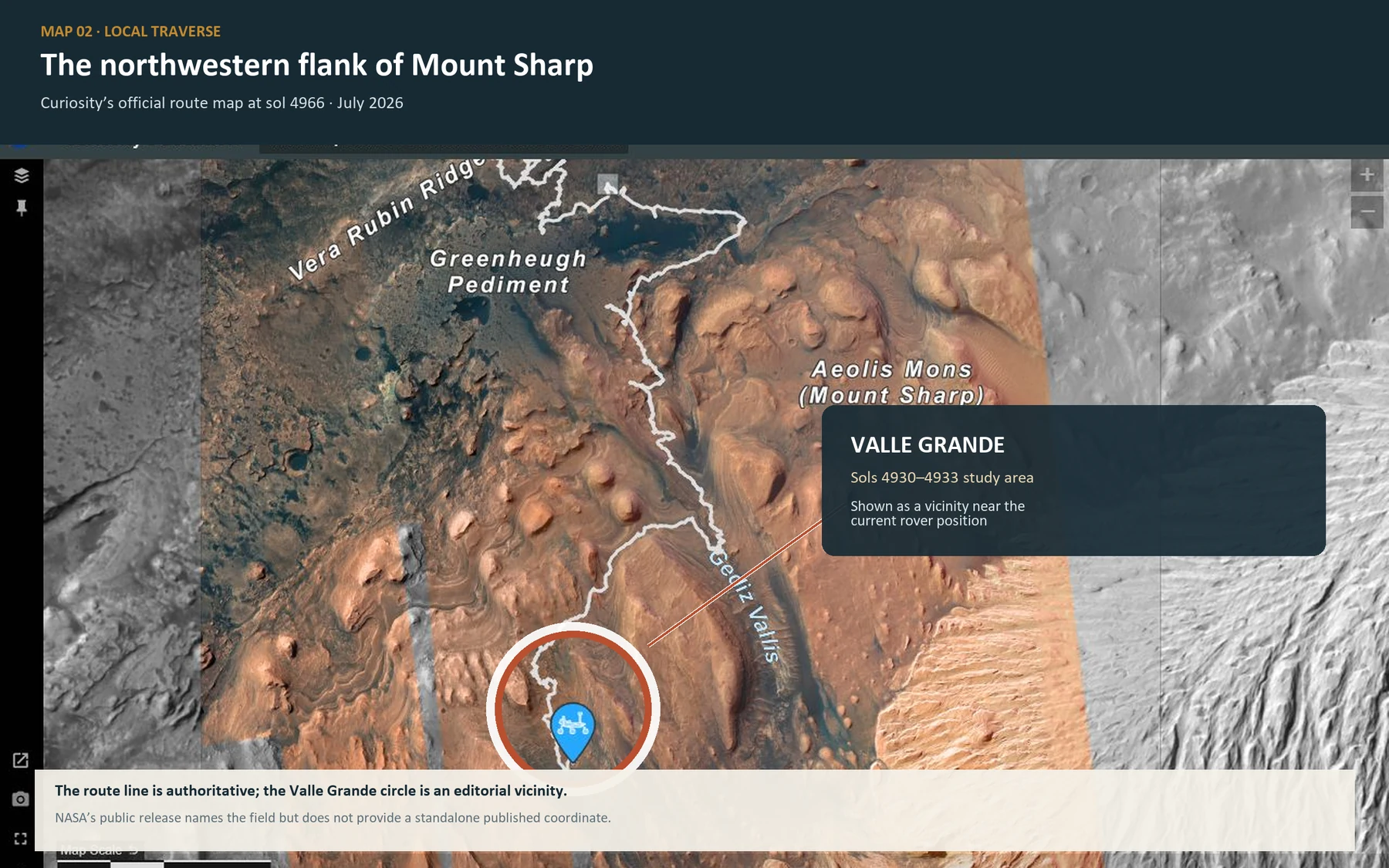
The official route map at sol 4966 shows Curiosity deep into its climb on the northwestern flank of Mount Sharp. The white traverse and blue rover pin are from NASA’s live map; the Valle Grande circle is an editorial vicinity for the sol 4930–4933 study area, not a published coordinate. Base: NASA/JPL-Caltech/University of Arizona. Graphic annotation: Apeira Astra. [4]
The map also reveals an important mismatch of scale. Orbital cameras can distinguish the broad light- and dark-toned units that guide the rover’s route, but a 4-centimeter cell is far below the resolution of a route-planning image. Mission scientists had mapped surface textures from orbit; only on arrival could they see that the “smooth” ground was crowded with tiny polygons. [7]
03 When a crack becomes a ridge
A fracture begins as empty space. Valle Grande’s polygons are often expressed as edges that resist erosion, which means the visible pattern may be the cast of an older crack system rather than the cracks in their original form.
On Earth and Mars, a common sequence works like this:
Stress opens fractures in sediment or rock.
Sand, silt or mineral-bearing water enters the openings.
The fill becomes cemented or otherwise harder than the host material.
Erosion removes the softer surroundings faster than the fill.
The former cracks remain as raised ridges.
Curiosity has documented versions of this transformation elsewhere in Gale. At Yellowknife Bay, ChemCam found resistant fracture-filling ridges with chemical layering on submillimeter scales—evidence that fluids and depositional conditions changed while the fractures were being filled. [8]
This inversion is the key to reading Valle Grande. The topography visible today may combine at least three eras: the moment the fractures opened, the later episode in which material entered or cemented them, and the much more recent wind erosion that exposed the network.
Important distinction — a raised polygon is not automatically a dried lake bed.
The cell outline may preserve an original shrinkage crack. It may also record thermal contraction, subsurface compaction or more than one generation of fracturing. Mineral cement can preserve all of those histories in superficially similar relief.
04 Three ways to make a polygon

Three process families named by NASA for the Valle Grande field. The sketches are explanatory, not reconstructions of the site. Graphic: Apeira Astra; scientific basis: NASA/JPL-Caltech and prior Curiosity fracture studies. [1]
Drying
Water-rich mud loses volume as it dries. Tensile stress builds until cracks open and divide the surface into cells. A first episode often produces many T-shaped junctions; repeated wetting and drying can reorganize junctions toward angles closer to 120 degrees, creating more hexagonal networks.
That geometric clue is useful, but it is not a universal decoder ring. Sediment thickness, grain size, pre-existing weaknesses and later erosion all modify the pattern.
Heating and cooling
Materials expand when warmed and contract when cooled. Repeated temperature swings can accumulate stress and generate polygonal fracture networks, including in frozen ground. Thermal-contraction polygons are widespread on Mars at much larger scales.
Valle Grande’s centimeter cells and lithified appearance do not by themselves establish an ice-wedge landscape. “Thermal cycling” is a family of stress mechanisms to be tested against the rock context, not a label already attached to the field.
Burial, compaction and dewatering
Sediment is squeezed as younger material piles above it. Grains rearrange; pore pressure changes; water can be expelled. The resulting stress may create fractures below the surface, long after deposition. A 2025 analysis of fracture networks at Maria Gordon Notch used their orientation and cross-cutting relations to reconstruct burial and exhumation on Mount Sharp—the kind of structural detective work Valle Grande may eventually support. [9]
These candidates are not mutually exclusive. Mud could crack near the surface, be buried, fracture again, receive mineral-rich fluids and then be exhumed. Curiosity has seen rocks in Gale that preserve multiple generations of cracks and veins.
05 The rover’s field kit
The cameras reveal the geometry, but the decisive evidence may be chemical.
Mastcam maps the field at landscape and hand-sample scales. From mosaics and stereo coverage, researchers can measure cell dimensions, ridge continuity, junction angles and the network’s relation to bedding.
MAHLI, the Mars Hand Lens Imager on the robotic arm, supplies close views of ridge texture, grains and contacts. A clean contact between a ridge and its host can show whether the ridge is a sediment fill, a mineral vein or simply an uneroded portion of the same material.
APXS, the Alpha Particle X-ray Spectrometer, measures bulk elemental chemistry after the arm places it against a target. Paired observations of a ridge and a polygon center can test whether the two are chemically distinct.
ChemCam fires laser pulses at a target and reads the light from the resulting plasma. Its LIBS measurements provide chemistry from a distance, while the Remote Micro-Imager records fine structure. During the Valle Grande campaign, the team planned ChemCam and arm observations on ridges, polygon centers and veins rather than treating the patterned surface as a single homogeneous unit. [7] [10]
The operational blogs show how deliberately the comparison was built. APXS and MAHLI were directed to both raised edges and cell interiors. ChemCam targeted multiple ridges and a polygon center. Mastcam extended the context around each small chemical spot. That paired design matters: an absolute composition can be ambiguous; a consistent ridge-versus-center difference is much more diagnostic.
The rover also crossed from lighter-toned material toward a darker, rougher band. Changes in preservation across that transition may help separate the original fracture network from the effects of weathering. The same fractures can look bold in one rock and faint in another if cement strength or erosion rate changes.
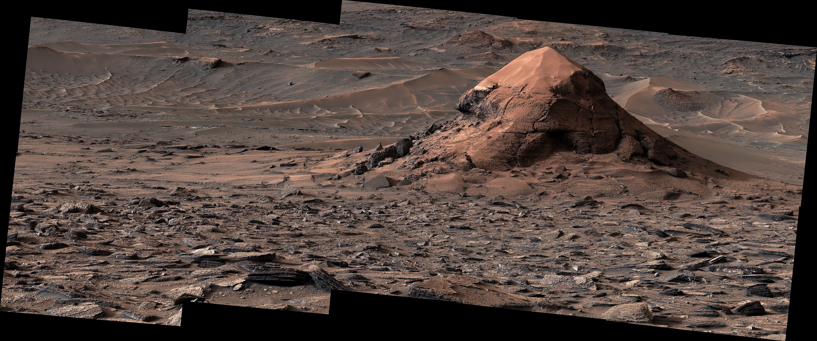
Miraflores, photographed June 11, 2026, is about 6 meters tall. Polygonal textures occur around the butte and appear to wrap across its lower flanks, helping the team test whether the pattern follows a layer, a surface or a broader rock unit. Credit: NASA/JPL-Caltech/MSSS, PIA26730. [1]
06 Mars has shown Curiosity this trick before
Valle Grande is unprecedented for its extent in a rover panorama, not because polygons are new to the mission.
At Old Soaker, a slab of Murray formation mudstone examined in 2016, Curiosity found four- and five-sided polygons only 1 to 2 centimeters across. Their size, form and geologic setting were consistent with a thin mud layer that cracked while drying more than three billion years ago. Some cracks later collected sediment; others were crossed by bright calcium-sulfate veins from groundwater circulating through a younger fracture system. [11]
At Pontours, in the transition from clay-bearing to sulfate-bearing strata, the rover found centimeter-scale polygonal ridges joined at Y-shaped junctions. A 2023 Nature paper interpreted those sulfate-rich ridges as cracks repeatedly reactivated by wet–dry cycles, possibly seasonal. The repeated cycles softened the initial T-junction geometry toward a hexagonal network. [12]
And during 2024 and 2025, well before Valle Grande, mission planners repeatedly paired chemistry and imaging on polygon edges and interiors. In one 2025 workspace, the preserved ridges stood roughly a centimeter high. The team’s stated possibilities included stress, thermal expansion and contraction, and hydration or dehydration. [13] [14]
Those earlier sites prove that Curiosity knows how to recognize and test polygonal fractures. They do not prove that Valle Grande formed the same way. Similar shapes can be produced by different histories—a classic problem of planetary geology, where scientists often see only the final exposed surface.
07 A page in Gale’s climate archive
Gale Crater was chosen because its rocks contain a vertically organized record of changing environments. The lower mound includes clay-bearing layers associated with water-rock interaction; higher sections contain abundant sulfates and other deposits associated with a long environmental transition. But Mount Sharp is not a simple bar chart from “wet” at the bottom to “dry” at the top. Lakes, rivers, dunes, groundwater, burial, cementation and wind erosion overlap in the record.
Early in the mission, Curiosity’s work at Yellowknife Bay established that Gale once held a freshwater lake environment with the basic chemical ingredients and conditions needed to support microbial life. Later discoveries extended the history of surface and subsurface water and revealed organic molecules in ancient sedimentary rock. None of that is evidence that life existed on Mars. It establishes past habitability: environments in which known microbial life could, in principle, have functioned. [15]
The polygons add a different kind of information. Lake deposits tell us that water accumulated. Desiccation cracks, if demonstrated, tell us that wet ground became dry. Mineralized fractures record water moving through rock after burial. Thermal fractures constrain mechanical conditions closer to the surface. One exposure can therefore preserve climate, sedimentation and diagenesis—the chemical and physical changes that happen after sediment is deposited.
That is why the distinction among mechanisms matters. If Valle Grande is an enormous preserved drying surface, it could mark an episode of exposure across a remarkably continuous layer. If it formed through compaction and dewatering, it instead records the load and fluid pressure of burial. If thermal stress dominated, it speaks to the environment after the rock was nearer the surface. A hybrid history may be more realistic than any single option.
08 What we know—and what we do not
STRONGLY SUPPORTED
The patterned terrain is extensive.
The 360-degree Mastcam mosaic shows polygonal textures around the rover and on the nearby Miraflores butte.
The cells are centimeter-scale.
NASA reports widths of 4 to 8 centimeters, much smaller than the great thermal-contraction polygons commonly mapped from orbit.
The mission is testing morphology and chemistry.
Mastcam, MAHLI, APXS and ChemCam observations compare ridges, interiors, veins and neighboring rock.
Curiosity has driven more than 37 kilometers to reach this part of the stratigraphy.
The field lies on the northwestern ascent of Mount Sharp, not on the original crater-floor landing plain.
PLAUSIBLE, NOT YET DECIDED
The polygons began as drying cracks.
This is consistent with some earlier Curiosity sites, but NASA explicitly retains thermal cycling and burial-related dewatering as alternatives.
The ridges are fracture fills.
Their relief suggests resistant material, but the mineralogy and detailed relation to the host rock must do the discriminating.
One process acted across the entire field.
Visual continuity is suggestive; multiple fracture generations or preservation states could overlap.
OPEN QUESTIONS
When did the cracks form?
At deposition, during shallow exposure, deep in burial or after exhumation?
What fills the ridges?
Sediment, sulfate-bearing cement, another mineral assemblage or material close to the host rock?
How far does the network extend?
The rover can see to the horizon and orbiters can map the unit, but neither view directly measures the hidden three-dimensional fracture system.
Does Valle Grande mark a regional event?
Connecting this field to other polygon-bearing outcrops requires stratigraphic correlation, not resemblance alone.
A landscape becomes an experiment
The most arresting Mars images often appear self-explanatory. A delta implies a river. Rounded pebbles imply transport. Cracks imply drying.
In practice, geology earns its conclusions by resisting that first certainty. Valle Grande looks like a dried surface, but Curiosity’s long record in Gale shows how many events can be superimposed on a single texture. Sediment was deposited, buried, fractured, invaded by fluids, cemented, lifted into the reach of erosion and finally scoured into the pattern visible today. The order of those verbs is the science problem.
Fourteen years after landing, Curiosity is still doing what it was built to do: turning a landscape into a set of testable comparisons. A ridge against a cell. A light-toned unit against a dark one. A T-junction against a Y-junction. A familiar texture against a field unlike any the mission has seen.
The geometry is already written. The rover is working out which chapter of Mars wrote it.
Sources
NASA Jet Propulsion Laboratory. “NASA’s Curiosity Mars Rover Discovers Field of Honeycomb Textures.” July 29, 2026. Primary mission release and image source.
Chen, A. et al. “Assessment of the Mars Science Laboratory Entry, Descent, and Landing Simulation.” AAS 13-420. Landing position: 4.5895°S, 137.4417°E.
NASA Science. “Mount Sharp Inside Gale Crater, Mars.” NASA/JPL-Caltech/ESA/DLR/FU Berlin/MSSS.
NASA Science. “Curiosity Rover Location Map.” Live traverse and orbital context map.
NASA Mars Science Laboratory team. “Sols 4954–4960: Celebrating Our Rover Engineers Past and Present.” July 23, 2026.
NASA Science. “Topography of Gale Crater.” MOLA-derived elevation context, NASA/JPL-Caltech.
NASA Mars Science Laboratory team. “Sols 4927–4933: Let’s Drive to That Smooth Area.” June 24, 2026.
Léveillé, R. J. et al. “Chemistry of fracture-filling raised ridges in Yellowknife Bay, Gale Crater: Window into past aqueous activity and habitability on Mars.” Journal of Geophysical Research: Planets 119 (2014).
Banham, S. G. et al. “A Burial History of the Sedimentary Succession Preserved in Aeolis Mons, as Recorded by Fracture Networks at Maria Gordon Notch, Gale Crater, Mars.” Journal of Geophysical Research: Planets (2025).
NASA Mars Science Laboratory team. “Sols 4934–4940: In the Land of the Polygons.” July 1, 2026.
NASA Science. “Possible Mud Cracks Preserved in Martian Rock.” Old Soaker image and interpretation, January 17, 2017.
Rapin, W. et al. “Sustained wet–dry cycling on early Mars.” Nature 620 (2023): 299–302.
NASA Mars Science Laboratory team. “Sol 4370–4371: All About the Polygons.” November 23, 2024.
NASA Mars Science Laboratory team. “Sols 4529–4531: Honeycombs and Waffles… on Mars!.” May 6, 2025.
NASA Science. “Curiosity Science Highlights.” Mission synthesis of ancient habitability, water and organic chemistry.
Editorial methodology: the field dimensions, dates, place names and candidate mechanisms were checked against NASA’s July 29 mission release and contemporaneous rover-planning logs. Earlier analogues were traced to NASA image documentation and peer-reviewed fracture studies. The two maps retain NASA base imagery and label editorial approximations explicitly; the mechanism diagram is an original Apeira Astra explanatory graphic.
Image use and independence
Mission photographs and base maps are credited in their captions to NASA, JPL-Caltech, MSSS, the University of Arizona, and other named contributors as applicable. NASA content is used editorially and with acknowledgement under the NASA Images and Media Usage Guidelines and the JPL Image Use Policy. Apeira Astra is an independent publication and is not affiliated with, sponsored by, or endorsed by NASA, JPL, Caltech, MSSS, or the University of Arizona.